


A typical feature of the Wadden Sea is a seaward barrier of sandy islands and shoals. They are a result of moderate tidal ranges as well as sand supplied from offshore by waves and then moved by wind.
The moderate, but constant sea level rise has led to an increase of tides. Today they range from 1.5 to 4 meters. Below a tidal range of about 0.5 m, unbroken barrier spits and lagoons have developed. Above approximately 3.5 m, barrier islands no longer occur due to the large tidal prisms.
In the southern Wadden Sea, twelve major barrier islands located 5 to 15 km off the mainland shelter the tidal area against waves generated by northwesterly and northerly winds. In this part, the sediment imported from the sea does not fully compensate for the sea-level rise and the islands migrate landwards.
In the central Wadden Sea, tidal ranges often exceed 3 m. Here, there are four estuaries causing a lower and more variable salinity than in the other two regions. A seaward chain of barrier islands is absent. In this part, sediment import appears to balance sea-level rise.
In the northern Wadden Sea, eight islands and elevated sandbars form a seaward barrier 5 to 25 km off the mainland. They provide shelter against waves generated by the prevailing westerly winds. Mostly, sediment supply does not compensate for sea-level rise, except for an oversupply between the islands of Rømø and Fanø. Several marsh islands are scattered across the tidal area. These are remnants of a coherent marshland which became submerged in late medieval times. In the North, some Pleistocene cliffs meet the sea.
![]()
Satellite image of the Wadden Sea with its three sub-regions. © albedo39 Satellitenbildwerkstatt e.K. (image processing), Brockmann Consult GmbH (scientific consulting), raw data: U.S. Geological Survey.
Hydrologically, the Wadden Sea is a series of 39 distinctive tidal basins. Each of these basins displays the following features: salt marshes, tidal flats, tidal gullies, barrier islands and ebb-tidal deltas.
The tidal basins correlate with barrier islands and elevated sandbars. Between them, the tidal flow is compressed and scours deep tidal inlets of up to 30 m depth and strong currents. Behind the barrier islands, most inlets branch into major tidal channels which, in turn, branch into successively smaller tidal creeks or runnels in a recurrent fractal pattern.
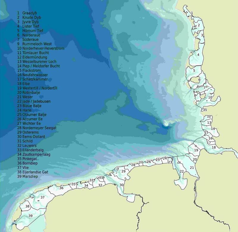
Distribution of the 39 tidal basins in the Wadden Sea. © CWSS.
Waves, tides and wind are important characteristics of the Wadden Sea Area. Their interplay dictates the Wadden Sea’s day-to-day appearance.
Twice a day, the incoming tide moves an average volume of 15 km³ of seawater through the tidal channels and inlets into the tidal basins, where roughly the same volume remains at low tide. Therefore, at a normal high tide, the Wadden Sea carries up to 30 km³ of water.
Strong onshore winds, however, can push in more water causing high tides to reach 4 m above normal. If those, mostly westerly winds prevail, tidal flats often remain submerged for several days. This is one of the reasons why marine organisms dominate terrestrial organisms in the Wadden Sea’s tidal zone.
Strong offshore winds from the East are less frequent, but when they occur, they can push low tides down to 1.5 m below normal. On these days, higher sand banks and tidal flats that usually submerge during high tide are left dry and ferries to some islands have to remain in the harbours.
Due to storms and change in sea level, the geomorphology of the Wadden Sea remains very dynamic. Every day it can show a new face. In the course of time, new islands emerge, such as Norderoog (DE), and others disappear, such as Bosch (NL), Buise (DE) and Jordsand (DK). Nowhere else on the planet is there such diverse and dynamic coastline of this scale.